Manage salinity and recharge – East Gippsland
According to the Victorian Dryland Salinity Update, January 2013 there is 273 ha of salt affected land in East Gippsland with another 24,160 ha in the West Gippsland catchment. Saline soils are present in the Bengworden area and immediately adjacent to the Gippsland Lakes.
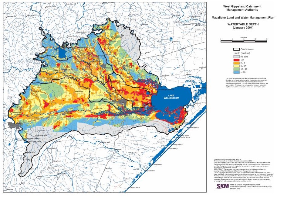
Figure 1 outlines the location of salt affected land in the West Gippsland catchment. This area is within the boundary of the EverGraze East Gippsland region. The depth to the water table is directly correlated to the threat of salinity and is explained further below. The areas shaded in red have water within 2m of the surface and thus can become salt affected.
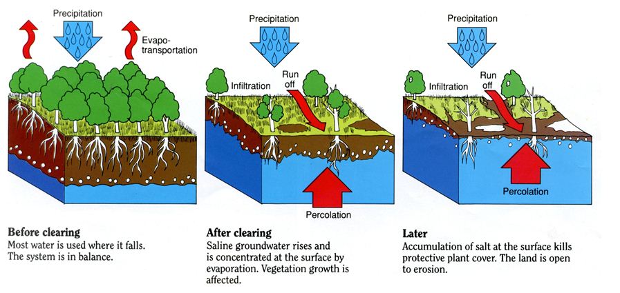
Some of the salinity in East Gippsland is a result of the process described in Figure 2 – known as the Discharge/Recharge model. The groundwater or water table is fed from groundwater coming from the Great Diving Range or the Strzelecki Range or local rain.
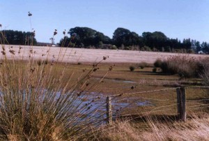
IIn areas surrounding the Gippsland Lakes, the water from the lakes is moving out of the lakes into groundwater. This water is as salty as sea water (30,000 parts salt per million parts water) and salinity due to capillary rise in this case has caused considerable damage to farm land adjacent to the lakes. This form of salinisation can be seen in the image below.
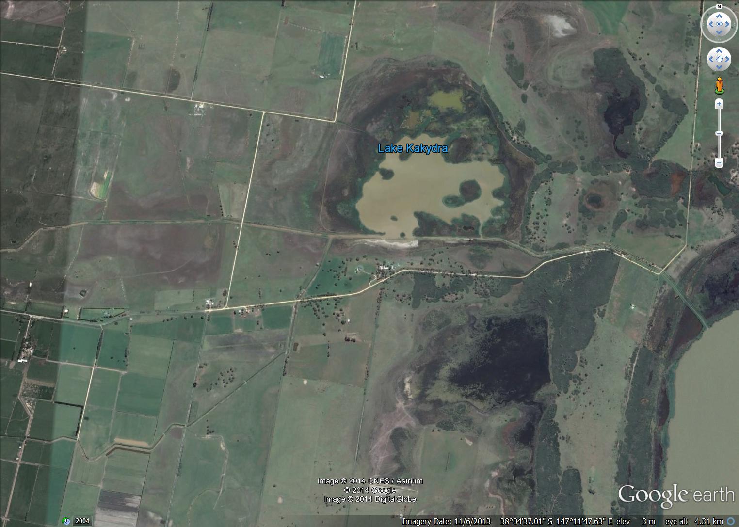
Source Google Earth
Over extraction of fresh groundwater from an aquifer next to saltwater can reduce the water pressure and draw saltwater into the aquifer. This risk is most prevalent in coastal areas where seawater is able to infiltrate fresh aquifers. Saltwater intrusions can cause groundwater to become too salty for drinking, irrigation and also degrade environmental values.
Spotting salinity
Early signs of salinity, such as reduced vigour and stunting of improved pastures, are hard to distinguish and may not be noticed or incorrectly diagnosed. Salt sensitive species, such as clover, begin to thin out to be replaced with salt tolerant species, such as sea barley grass and spiny rush. Identifying plant species can be used as an indicator to see if an area is becoming saline. Further indicator species can be found here.
Soluble salts contain high levels of sodium and chloride which is toxic to plant species, such as sub clover and lucerne. Waterlogging is common around discharge sites which reduce plant growth. Other impacts include water quality decline due increased salt loading in waterways and death of existing native vegetation.
|
|
|
Managing the problem – a catchment approach
Managing salt affected land includes planting a combination of deep rooted perennial pastures with high density tree planting in recharge areas. Sowing salt tolerant pastures, such as tall wheat grass in discharge areas, can gain some minor production from the site and provide ground cover to minimise erosion. Ground cover over salt effected land is very effective in reducing evaporation from the capillary zone as the soil surface temperature is reduced by shading. Tall wheat grass and other salt-tolerant plants can be used where land is extremely salt affected. It is important to note that Tall wheat grass can become a weed risk if not managed correctly.
Rarely can one land manager solve a salinity problem. While sometimes causes and effects can be seen within a single farm, the cause and effects often cross property boundaries. Everyone in a catchment is affected by the agricultural activities within the catchment. Therefore effective salinity management requires a total catchment approach.
The long-term solution to salinity is to restore the balance of inputs and outputs of the soil-water system, by controlling the process of groundwater recharge. Treatment of salt affected land is an important component of salinity management.
Dryland Salinity
Dryland areas are easier to rehabilitate before the salinity and waterlogging become too severe, so early identification of the severity and extent is important. In combating salinity in dryland areas, large scale establishment of deep rooted plants such as trees and lucerne will be required to restore the water balance. In high rainfall areas plantation forestry may be one means of achieving the scale of tree planting required. Strategic tree planting as a part of a whole farm plan or catchment plan will also provide some benefit to recharge management. Deep-rooted perennial pastures are more likely to be effective in lower rainfall than in higher rainfall areas.
Irrigation salinity
Irrigation induced salinity is primarily addressed by reducing groundwater recharge wherever practically and economically feasible.
Groundwater pumping options have been adopted in West Gippsland where the pumped water is used on farm (including private pumps and Groundwater Control Pumps disposing to channels), rather than the saline water being disposed directly to rivers and lakes.
Irrigation induced salinity is an issue in the vicinity of the Macalister Irrigation District. The process is similar to the recharge/discharge process (Figure 2), but on a smaller scale. A farmer irrigating on one farm can become a recharge zone, and the dry paddock next door can be the discharge zone that is salinised by capillary rise. Ground water rising to the soil surface (via the capillary zone) causes salinity as evaporation occurs and salt remains on the soil surface. If this salt is not washed away in rainfall events or by irrigating that land, the salt can concentrate and the soil will become salt affected over time.
Salt can also concentrate in the water table over time as repeated irrigation results in water not used by the plants moving downwards. Macalister Irrigation District farmers have addressed this issue by;
- installing water saving technology including pipes and rises,
- switching to spray irrigation,
- developing whole farm plans that include irrigation infrastructure layout and
- scheduling with sophisticated soil moisture monitoring to reduce leakage.
These programs are outlined in the West Gippsland Salinity Management Plan 2005.
