Adoption of EverGraze Triple System will reduce recharge in the Wannon Catchment
Adoption of the EverGraze Triple system (lucerne, tall fescue and perennial ryegrass) has potential to reduce recharge and stream flows in the Wannon catchment, however the extent of impact depends on the area suitable for lucerne and the extent of adoption.
Key results
- Of the three systems trialled at Hamilton EverGraze Proof Site, the Triple pasture system (lucerne, perennial ryegrass and tall fescue) had the highest potential for reducing recharge, with lucerne planted on the crests fully controlling leakage below the root zone during the course of the experiment (see Lucerne reduces risk, provides options for livestock and prevents salinity). This system would need to be modified to utilise phalaris and lucerne in lower rainfall areas.
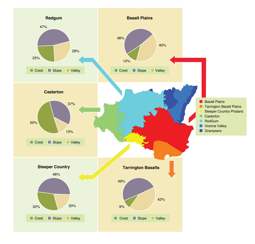
- The potential for the Triple system to reduce recharge in each sub-catchment was dependent on the area suited to lucerne – usually drier crests. The proportion of crests varied from 50% of the landscape in Casterton, 32% in Steeper country, 25% in Red Gum country, 12% in the Basalt Plains (the location of the Proof Site), and 9% in the Tarrington basalts.
- It was estimated that with 50% adoption of the Triple system in suitable areas throughout the catchment, compared to current practice, the potential for reduced recharge was around 5% in the Basalt Plains, 7% in Tarrington Basalts, 13% in Steeper Country, while the potential in Casterton and the Red Gum country were approximately 26% and 23% respectively.
- The increased use of perennial pastures (>50% adoption of the Triple system) across the Wannon catchment also resulted in some reductions in stream flow, water catchment and potential dam fill. However an increase in the period when farm dams are dry only occurs at higher levels of perennial adoption.
Read more about this research
Introduction
[expand title=” ” swaptitle=” ” tag=”h4″ elwraptag=”div” elwrapclass=”expend-collapse-wrapper”]
The control of recharge resulting in dryland salinity was a primary target for the EverGraze pasture systems being developed and trialled at Hamilton. Soil salinity had increased markedly over 50 years in the Corangamite and Glenelg Hopkins catchments. In Glenelg Hopkins, around 7% of water tables were within two metres of the surface and in the future this is predicted to remain a significant issue, particularly during wet periods
Over the past 100 years, the pasture base in South West Victoria has changed from native perennials to a mix of annuals and winter active perennials. In addition, many of the current perennial pastures contain less than 30% perennial species and others are being replaced by the rapid expansion of high rainfall annual cropping systems. The Hamilton Proof Site found that incorporating lucerne into perennial farming systems significantly reduced leakage below the root zone. Environmental modelling using a Catchment Assessment Tool (CATPlus) was undertaken to determine the impact of implementing these systems on the surrounding catchments.
[/expand]
What was done?
Hamilton Proof Site systems
[expand title=” ” swaptitle=” ” tag=”h4″ elwraptag=”div” elwrapclass=”expend-collapse-wrapper”]
EverGraze Hamilton trialled pasture systems, based on perennials including perennial ryegrass, lucerne, tall fescue, chicory and kikuyu matched to landscape to extend the growing season and increase profit from livestock production while reducing groundwater recharge. Full details of the experiment can be found on the Hamilton Systems Experiment page. In summary, the pasture systems were:
- Perennial Ryegrass System; early flowering ryegrass (cv. Fitzroy) on the crest, mid flowering ryegrass (Avalon) on the slopes and late season ryegrass (cv. Banquet) on the valley floors.
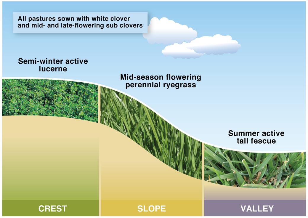
- Triple System; where perennial ryegrass was replaced with semi winter active lucerne (cv. SARDI Seven), on the crests and summer active tall fescue (cv. Quantum) on the valley floors.
- Novel System; Chicory (cv. Grasslands Puna) was used on the crests, Italian (2006, 2007)/late finishing perennial ryegrass (cv. Banquet) (2008) ryegrass on the slopes and kikuyu (cv. Whittet) on the valley floors.
All pastures were sown or oversown with a mix of subterranean clovers (cv. Leura and Gosse) and white clover (cv. Mink).
Of the three systems, the Triple system (Figure 1) was found to have the highest potential for recharge control, and was therefore modelled to determine the potential impact of adoption of this system in the Wannon catchment.
Applying the Triple system to the Wannon catchment
[expand title=” ” swaptitle=” ” tag=”h4″ elwraptag=”div” elwrapclass=”expend-collapse-wrapper”]
The Wannon catchment (Figure 2) located in southwest Victoria was chosen for the study area. In order to apply the model to the whole catchment, the Triple system needed to be modified as the lower rainfall parts of the Wannon catchment are unsuitable for growing both tall fescue and perennial ryegrass due to persistence problems. The landscape was therefore grouped and appropriate species allocated to each of the crest, slope and valley floor in each grouping (Table 1). The percentage of area defined as crest, slopes and valleys is presented in Figure 3.
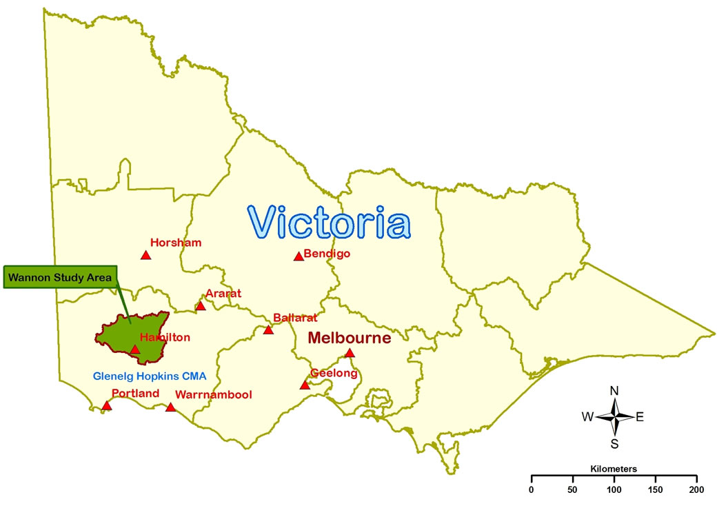
Table 1 Adaptation of the Triple system species for each landform and landscape grouping in the Wannon catchment
| Landscape grouping | Crest | Slope | Valley |
| Basalt Plains | Lucerne | Perennial ryegrass | Tall fescue |
| Tarrington Basalts | Lucerne | Perennial ryegrass | Tall fescue |
| Steeper Country | Lucerne | Phalaris | Phalaris |
| Casterton 1 | Lucerne | Phalaris | Phalaris |
| Casterton 2 | Phalaris | Phalaris | Lucerne |
| Red Gum | Lucerne | Phalaris | Phalaris |
For each land grouping zone a range of different scenarios were tested to determine modelled recharge response from adoption of the Triple system. Recharge is reported for each scenario as a mean annual recharge between 1957 and 2008. Therefore, adoption of a system attempted to take into account the area of that system available. This is especially important for the Basalt Plains as 50% of the land area was from the “Slope” land class which was planted to perennial ryegrass which has a very similar water use pattern to annual ryegrass. Within the EverGraze Triple Pasture System, lucerne has the highest potential to use water and control recharge but it is also the most restricted in its adaptability to different land classes due to its sensitivity to poor drainage and waterlogging. For this reason, the results are based on land use and generally based on pasture systems with a low percentage of lucerne.
To allow a comparison of recharge control for various land-use scenarios in the Wannon catchment the following results are presented relative to the best and worst results possible within the different catchment areas. The best and worst results are shown as green bars. Using modelling, the largest increase in recharge would occur if presently cleared land were fully replaced by annual grasses (Annual pasture 100%). The largest reduction in recharge would occur if all land was fully replaced by tree plantations (Trees 100%). The EverGraze Triple system only had a minor impact on recharge compared to current practise.e Figure 4 also shows the reduction in recharge that would occur if 25% of the catchment was sown to lucerne. These is only a hypothetical comparison as lucerne can only be grown on a limited area due to soil and waterlogging constraints. However, it shows that using a deep rooted summer active species can reduce recharge by about 25% compared to current pasture practises.
[/expand]
What was found?
Potential for 5% reduction in recharge with 50% adoption of the Triple system on the Basalt Plains
[expand title=” ” swaptitle=” ” tag=”h4″ elwraptag=”div” elwrapclass=”expend-collapse-wrapper”]
The Basalt Plains covers 30% of the Wannon catchment area. The modelled current practice land use was 90% grazing land (50% perennial ryegrass and 50% annual ryegrass) and 10% cropping land.
Table 2 shows the percentage of each land use for the six scenarios modelled. Each scenario has a low percentage of lucerne based on the 12% crest area available for the Basalt Plains (Figure 3). As lucerne will have the greatest impact on recharge control, the change in recharge due to adoption of the Triple system is small when compared to current practice (Table 2).
Table 2 Percentage land use mix for each scenario
| Crop | Perennial Ryegrass | Annual Ryegrass | Tall Fescue | Lucerne | Tree | |
| Annual pasture 100% | 100 | |||||
| Current Practice | 10 | 45 | 45 | |||
| 10% Triple system | 10 | 45 | 40 | 4 | 1 | |
| 25% Triple system | 10 | 45 | 32 | 10 | 3 | |
| 50% Triple system | 10 | 45 | 19 | 20 | 6 | |
| Trees 100% | 100 |

Potential for 7% reduction in recharge with 50% adoption of the Triple system on the Tarrington Basalts
[expand title=” ” swaptitle=” ” tag=”h4″ elwraptag=”div” elwrapclass=”expend-collapse-wrapper”]
The Tarrington Basalts represent 8% of the Wannon catchment. The modelled current practice land use was 80% grazing land (40% perennial and 40% annual ryegrass) and 20% cropping land.
Table 3 shows the percentage of each land use for the six scenarios modelled. Each scenario has a low percentage of lucerne based on the 9% crest area available for the Basalt Plains (Figure 3). As lucerne will have the greatest impact on recharge control, the change in recharge due to EverGraze adoption is small when compared to current practice (Figure 5)
Table 3 Percentage land use mix for each scenario
| Crop | Perennial Ryegrass | Annual Ryegrass | Tall Fescue | Lucerne | Tree | |
| Annual pasture 100% | 100 | |||||
| Current Practice | 20 | 40 | 40 | |||
| 10% Triple system | 20 | 40 | 35 | 4 | 1 | |
| 25% Triple system | 20 | 40 | 27 | 10 | 3 | |
| 50% Triple system | 20 | 40 | 14 | 20 | 6 | |
| Trees 100% | 100 |

Potential for 13% reduction in recharge with 50% adoption of the Triple system on Steeper Country
[expand title=” ” swaptitle=” ” tag=”h4″ elwraptag=”div” elwrapclass=”expend-collapse-wrapper”]
The Steeper Country represents 4% of the Wannon catchment area. The modelled current practice land use was 90% annual ryegrass and 10% phalaris.
Table 4 shows the percentage of each land use for the six scenarios modelled. Thirty two per cent of the Steeper Country is crest area that is suitable for lucerne establishment (Figure 3 ). As lucerne will have the greatest impact on recharge control the change in recharge due to EverGraze adoption is moderate compared to current practice (Figure 6)
Table 4 Percentage land use mix for each scenario
| Crop | Annual Ryegrass | Phalaris | Lucerne | Tree | |
| Annual pasture 100% | 100 | ||||
| Current Practice | 90 | 10 | |||
| 10% Triple system | 80 | 17 | 3 | ||
| 25% Triple system | 65 | 27 | 8 | ||
| 50% Triple system | 45 | 40 | 15 | ||
| Trees 100% | 100 |

Potential for 26% reduction in recharge with 50% adoption of Triple system on Casterton
[expand title=” ” swaptitle=” ” tag=”h4″ elwraptag=”div” elwrapclass=”expend-collapse-wrapper”]
The Casterton land grouping represents 14% of the Wannon catchment area. The modelled current practice land use was 60% annual ryegrass and 40% phalaris.
There were two EverGraze systems identified in the Casterton area. The first is “Casterton 1” where lucerne is planted on the crest (50% of total land area) and the second is “Casterton 2” where lucerne is planted in the valley (13% of total land area, Table 1).
For each scenario of the “Casterton 1” run the percentage of each land use is shown in Table 5 with recharge impacts shown in Figure 7.
Table 5 Percentage land use mix for each scenario in Casterton 1
| Crop | Annual Ryegrass | Phalaris | Lucerne | Tree | |
| Annual pasture 100% | 100 | ||||
| Current Practice | 60 | 40 | |||
| 10% Triple system | 50 | 45 | 5 | ||
| 25% Triple system | 35 | 52 | 13 | ||
| 50% Triple system | 10 | 65 | 25 | ||
| Trees 100% | 100 |

For each scenario of the “Casterton 2” run the percentage of each land use is shown in Table 6 with recharge impacts shown in Figure 8.
Table 6 Percentage land use mix for each scenario in Casterton 2
| Crop | Annual Ryegrass | Phalaris | Lucerne | Tree | |
| Annual pasture 100% | 100 | ||||
| Current Practice | 60 | 40 | |||
| 10% Triple system | 50 | 48 | 2 | ||
| 25% Triple system | 35 | 60 | 5 | ||
| 50% Triple system | 10 | 80 | 10 | ||
| Trees 100% | 100 |

The establishment of lucerne on crests and the doubling of phalaris on slopes combined to reduce recharge by 26% compared with recharge under current practice. This is the most significant impact modelled over any of the land groupings within the Wannon catchment.
[/expand]
Potential for 23% reduction in recharge with 50% adoption of EverGraze on Red Gum country
[expand title=” ” swaptitle=” ” tag=”h4″ elwraptag=”div” elwrapclass=”expend-collapse-wrapper”]
The Red Gum country represents 28% of the Wannon catchment area. The modelled current land use was 90% annual ryegrass and 10% phalaris. Table 7 shows the percentage of each land use for the six scenarios modelled. The various recharge impacts are shown in Figure 9.
Table 7 Percentage land use mix for each scenario on Red Gum Country
| Crop | Annual Ryegrass | Phalaris | Lucerne | Tree | |
| Annual pasture 100% | 100 | ||||
| Current Practice | 90 | 10 | |||
| 10% Triple system | 80 | 17 | 3 | ||
| 25% Triple system | 65 | 27 | 8 | ||
| 50% Triple system | 45 | 40 | 15 | ||
| Trees 100% | 100 |

The adoption of EverGraze systems on 50% of the Red Gum country could potentially lead to a 23% reduction in recharge compared to the current land use practice.
[/expand]
Large increases in the use of perennials will reduce stream flows and dam fill
[expand title=” ” swaptitle=” ” tag=”h4″ elwraptag=”div” elwrapclass=”expend-collapse-wrapper”]
Modelling for the Wannon catchment in southwest Victoria tried to identify the potential impacts of increasing use of perennial species across the catchment on stream flow and water bodies such as farm dams and wetlands. The perennial species assessed include lucerne, tall fescue, native grasses and plantation forestry (softwood and hardwood).
The study found that:
- Under current practice conditions, farm dams maintained a sufficient water volume for stock for 96% of months. The majority of months when farm dams were empty occurred within the last decade, when rainfall was well below the long-term average.
- The increased use of perennial plants reduced stream flow and filling of farm dams. However, the location at which perennials were planted in the landscape and the type of perennials planted determined the magnitude of these impacts;
- If perennial pastures were established over the entire Wannon catchment the stream flows would be reduced by 37% (from 32 to 20 mm/year);
- If the tree cover was 100% over the entire Wannon catchment there would be a 57% reduction of stream flows;
- The largest increase in stream discharge would occur if presently cleared land were fully replaced by annual crops (Figure 10). A more realistic scenario is all presently cleared land planted to annual grasses (100% Annual). Both options increase stream flows in the Wannon catchment.
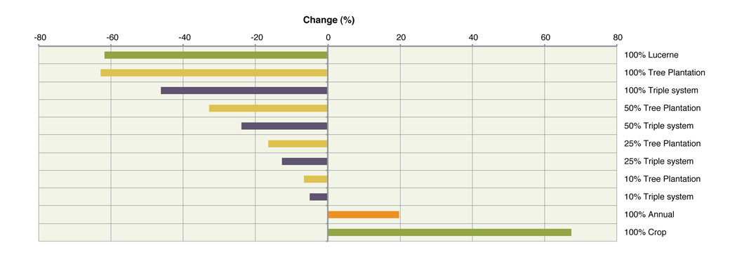
The difference in water use between lucerne and tree plantations was small. However, on average the decrease in catchment water yield due to tree plantations was 1.5 times that of perennial pastures (EverGraze Triple system adoption). This response was not uniform across the catchment, with tree plantations having a much larger impact within the Basalt Plains due to the relatively smaller areas available for lucerne (12% crests).
Our modelling also showed that as the perennial component of the catchment increases, the proportion of stream flow from direct runoff increases, and the component on base flow (groundwater) decreases. So although the amount of stream flow will decrease, water quality of the streams will improve due to less salinity entering the stream from groundwater.
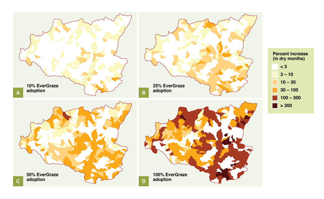
Increasing the use of the EverGraze Triple system in the Wannon Catchment increases the area of dry dams and percentage of months that dams are dry (Figure 11). However, only the highest levels of adoption (i.e. 100% EverGraze Triple system, Figure 11 d) caused extended dry periods across multiple months, as dam depth at 25% and 50% adoption levels showed a similar change in dam depth to current practice. At a local level on specific farms, the use of the Triple pasture system and specifically lucerne may extend the period that farm dams are dry and this could cause problems for the supply of water to livestock. However, careful farm planning of the areas sown to lucerne to avoid farm dam catchments can avoid these problems.
Case Study – The potential of lucerne pastures reduce recharge and runoff on “Corinda Vale” and in the Eumeralla Catchment of SW Vic
[expand title=” ” swaptitle=” ” tag=”h4″ elwraptag=”div” elwrapclass=”expend-collapse-wrapper”]
The CATPlus model was used to investigate potential impacts of farm management changes at a farm and catchment scale on recharge, runoff and erosion. To do this the various current practices and land management scenarios were run through the CATPlus model and the results for the main Corinda Vale property and the Eumeralla River Catchment were analysed.
On farm impact
Increasing soil fertility and stocking rate scenarios had little impact on recharge compared to current practice. However, with the addition of 25% lucerne there was a 14% reduction in recharge compared to current practice (reduction in recharge from 124 mm annually to 107 mm annually, Table 8).
Runoff and erosion were low for all three different pasture scenarios (Table 8), this was due to the relatively flat topography and the presence of perennial pastures. There were only six out of 40 years modelled for the current farming system in which annual runoff was greater than 1 mm, with maximum predicted runoff of 9 mm across the property in 1983.
Table 8 Alternative pasture and animal systems – Environmental factors
| Scenario | Recharge per year | Runoff per year | Erosion per year |
| Current farming system | 124 mm | 0.7 mm | 0.001 mm |
| Increased fertiliser and stocking rate | 123 mm | 0.6 mm | 0.001 mm |
| Increased fertiliser and stocking rate + 25% lucerne | 107 mm | 0.5 mm | 0.001 mm |
Increasing the proportion of lucerne on the farm increased the impact on mean annual recharge to the point where 100% lucerne would (in theory) reduce recharge down to 30mm/year. In practice, lucerne establishment across the whole farm is not realistic due to soil type, slope, rainfall, enterprise design and profitability.
Catchment
Across the Eumeralla catchment, increasing the proportion of lucerne had a similar impact on recharge to the farm scale. There was a 10-16% reduction in recharge due to the conversion of 25% of the catchment (as a proportion of every 1ha unit) to a 25% lucerne/perennial ryegrass pasture. The reduction in recharge was significantly affected by position within the landscape, namely soil type and slope.
[/expand]
What it all means
[expand title=” ” swaptitle=” ” tag=”h4″ elwraptag=”div” elwrapclass=”expend-collapse-wrapper”]
The adoption of the EverGraze Triple pasture system can reduce recharge significantly at an individual point in the landscape and on individual farms. However, if this pasture system was adopted widely across all suitable landscapes in the catchment, it could also significantly reduce recharge, stream flow and increase the period when farm dams are dry. This would have positive benefits for the control of dryland salinity but could negatively affect rivers, streams and wetlands and cause problems in water supply for domestic and livestock use. Accordingly these implications will need to be carefully considered.
An increase in the proportion of stream flow resulting from runoff (rather than base flow) may also improve water quality. It should be noted that it is only at the 100% adoption level that the effect on stream flow and farm dam levels occurs. The decrease in catchment water yield by tree plantations is 1.5 times that of implementing the EverGraze Triple system, so reduction in stream flows from a 100% adoption rate of trees is higher (63%) than for a 100% adoption of the Triple system (40%).
Placing the above result in context means that while there are possible negatives of the full adoption of the EverGraze Triple System on some environmental factors, the likely actual rates of adoption, use of farm planning and the management of land use by authorities would avoid the majority of these impacts. From a catchment and water resource management perspective it is important to consider the impact of increasing perenniality on wetlands and water courses to maintain catchment health, however the total area impacted within the Wannon catchment is small. While in localised spots within a catchment reduced recharge may be desirable (eg. to lower local ground water, reduce salinity or nutrient leaching) reducing recharge across the whole catchment will have flow on effects to ground and surface water resources that need to be carefully considered. In addition the farm productivity gains from these new perennial pasture systems would need to be weighed against their possible impacts and also compared to other changes in land use (e.g. trees or cropping) that could also result in negative consequences if they became more widespread in the absence of profitable and sustainable livestock grazing systems.
[/expand]
Putting the research into practice
[expand title=” ” swaptitle=” ” tag=”h4″ elwraptag=”div” elwrapclass=”expend-collapse-wrapper”]
When considering adoption of summer active perennials, farmers should have a good understanding of the water budget of their farm to ensure that water supplies for stock and domestic use remains adequate.
Farm water calculators are available that can be used to:
- Determine how much water is used on the property
- How much water can be stored on the property
- The potential supply of water from a range of water sources such as shed roof’s, waterways or groundwater and catchment runoff
- Determine how long the water will last on the property
- See how farm water supplies cope under different rainfall scenarios by adjusting the annual average rainfall and re-running the calculator
When planning investment in new water infrastructure or considering use of summer active pastures, consideration of the location and possible catchment effects both at the farm level (water catchment for dams) and in the locality (effects on water courses or neighbouring properties) is advised. Agriculture Victoria offers training in farm planning through the FarmPlan 21 program.
[/expand]
Acknowledgements
EverGraze and CATPlus are Future Farm Industries CRC research and delivery partnerships. The CATPlus modelling work undertaken for the Wannon catchment was led by Brendan Christy and consisted of other scientists and technical staff within Agriculture Victoria and the NSW Office of Environment and Heritage. EverGraze researchers along with other local farming experts helped this project focus its modelling research question to be relevant to their needs
The Hamilton EverGraze Proof Site team was led by Dr Ralph Behrendt and consisted of scientists and technical staff within Agriculture Victoria. An enthusiastic Regional Advisory Group consisting of farmers, consultants, extension officers and CMA staff provided significant input into the direction, management practices and interpretation of outcomes from the experiment and modelling to make them relevant to farmers.
Further Information
- The CATPlus Project: EverGraze catchments – Catchment scale recharge modelling for EverGraze
- Full report on the effect of EverGraze systems on farm dam and river flow
- I want to manage recharge and salinity in South West Victoria
- Hamilton EverGraze research message – Lucerne reduces risk, provides options for livestock and reduces recharge

